Works 100% Offline — GPS Only

Professional Off-Road Navigation Dashboard

Built for motorcycles, bicycles and rally cars. Neon speedometer, 3D navigation arrow, GPX tracks, 5-language voice guidance and SOS emergency — all in one screen.

◉ LIVE SIMULATION — Tap any button to interact
● GPS LOCK 9 SATELLITES
▲ 1,240 m ALTITUDE
14:32:07 LOCAL TIME
⛰ GRAVEL TERRAIN
⚡ 87% BATTERY
87
KM / H
DESTINATION
SUMMIT BASE
DISTANCE
4.2 km
ETA
14:47
BEARING
142°
GRADE
+8%
SURFACE
ROCKY TRAIL
⊕ SAVE
☰ WAYPOINTS
⚙ TOOLS
🗺 MAP
12+
Core Features
5
Voice Languages
100%
Works Offline
3
Adventure Modes

Everything you need
on the trail

Designed for riders who go where there are no roads, no signals, and no room for error.

Neon GPS Speedometer

Oversized neon-green digits readable at a glance in full sunlight. The arc gauge scales automatically to your adventure mode — 80 km/h for bicycle, 180 for motorcycle, 240 for rally. Speed comes directly from GPS, no sensors needed.

GPS DIRECT · KM/H · MPH

3D Navigation Arrow

Dynamic orange arrow rotates in real time based on your GPS heading vs. target bearing. No road network required — works in deserts, mountains, open terrain.

REAL BEARING · NO ROADS NEEDED
📊

Waypoint Info Panel

Destination name, live distance, ETA, bearing in degrees, terrain slope grade and surface type — all displayed in high-contrast cyan.

DISTANCE · ETA · GRADE
🗺

Offline Map

PMTiles vector map works fully offline. Zero mobile data needed in the deepest wilderness.

PMTILES · FLUTTER MAP
📂

GPX Import & Export

Import existing GPX tracks from device storage or paste XML from clipboard. Export your full recorded route as a standard GPX file to share with the adventure community or save for future navigation. Compatible with any GPX-aware app.

IMPORT · EXPORT · SHARE
🆘

SOS Emergency

One tap shares your exact GPS coordinates — latitude, longitude, altitude — as a ready-to-send text message. Critical when riding solo in remote areas.

LAT · LON · ALTITUDE
🎙

Voice Guidance — 5 Languages

Spoken arrival alerts in English, Arabic, French, Spanish and Chinese. Smart throttling prevents voice spam at minimum 8-second intervals.

EN · AR · FR · ES · ZH
📏

Trip Meter & Roadbook

Total and partial distance counters with elapsed time timer. Reset the partial counter at any checkpoint. Auto-generated roadbook lists all waypoints with cumulative distances.

TOTAL · PARTIAL · TIME
🧭

Mini Compass

Live heading indicator using device sensors — works independently of GPS signal.

SENSOR-BASED
🔒

Screen Always On

Wake Lock keeps the screen permanently lit. Immersive mode hides the OS status bar for a true full-screen dashboard experience.

WAKE LOCK · IMMERSIVE

Up and running
in 4 steps

Mount your device, set a destination, follow the arrow.

01
📲

Mount Your Device

Install on any Android phone or tablet. Mount it in landscape on your handlebars or dashboard.

02
📍

Set Your Destination

Save your current position as a waypoint, import a GPX track, or pick from saved points.

03

Follow the Arrow

The 3D arrow points at your destination. The cyan panel shows distance, ETA and slope live.

04
📤

Export Your Track

When done, export your full route as a GPX file to share or save for future reference.

Step-by-step for
every feature

Detailed walkthrough of each screen so you ride with full confidence.

GPS Arrow Pro Dashboard
01 — Main Dashboard

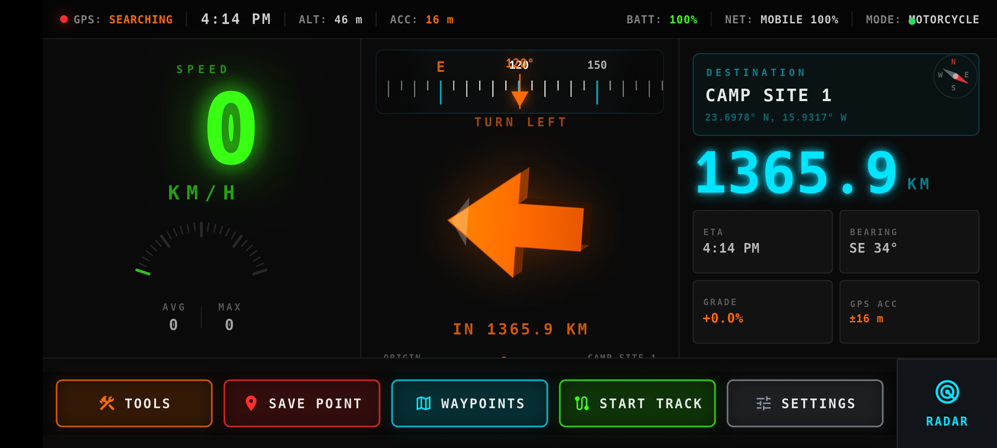
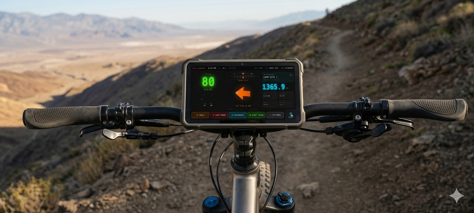
Your Complete Navigation Hub

Full-screen landscape layout with every critical data point on one screen — built to be read at a glance while riding at speed.

  • 1Top bar: GPS lock, satellites, clock, altitude, terrain, battery
  • 2Left: neon-green speedometer with arc gauge
  • 3Center: 3D orange arrow pointing at your waypoint
  • 4Right: cyan panel — name, distance, ETA, bearing, grade
  • 5Bottom: Save · Waypoints · Tools · Map
LandscapeFull-Screen Wake LockNeon UI
Navigation Arrow
02 — 3D Navigation Arrow

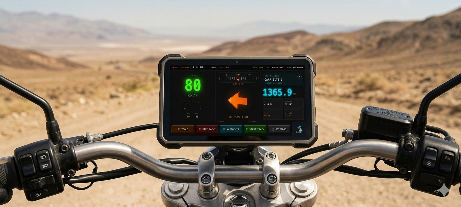
Always Points to Your Destination

The orange 3D arrow uses your GPS heading and waypoint bearing to show the exact direction — regardless of roads or trails.

  • 1Select any saved waypoint as your active target
  • 2The arrow rotates in real time based on heading vs. bearing angle
  • 3Arrow points up when you face your destination directly
  • 4Works in desert, forest, mountain — no road network needed
Real BearingGPS Heading 3D RenderNeon Orange
GPX Waypoints
03 — GPX & Waypoints

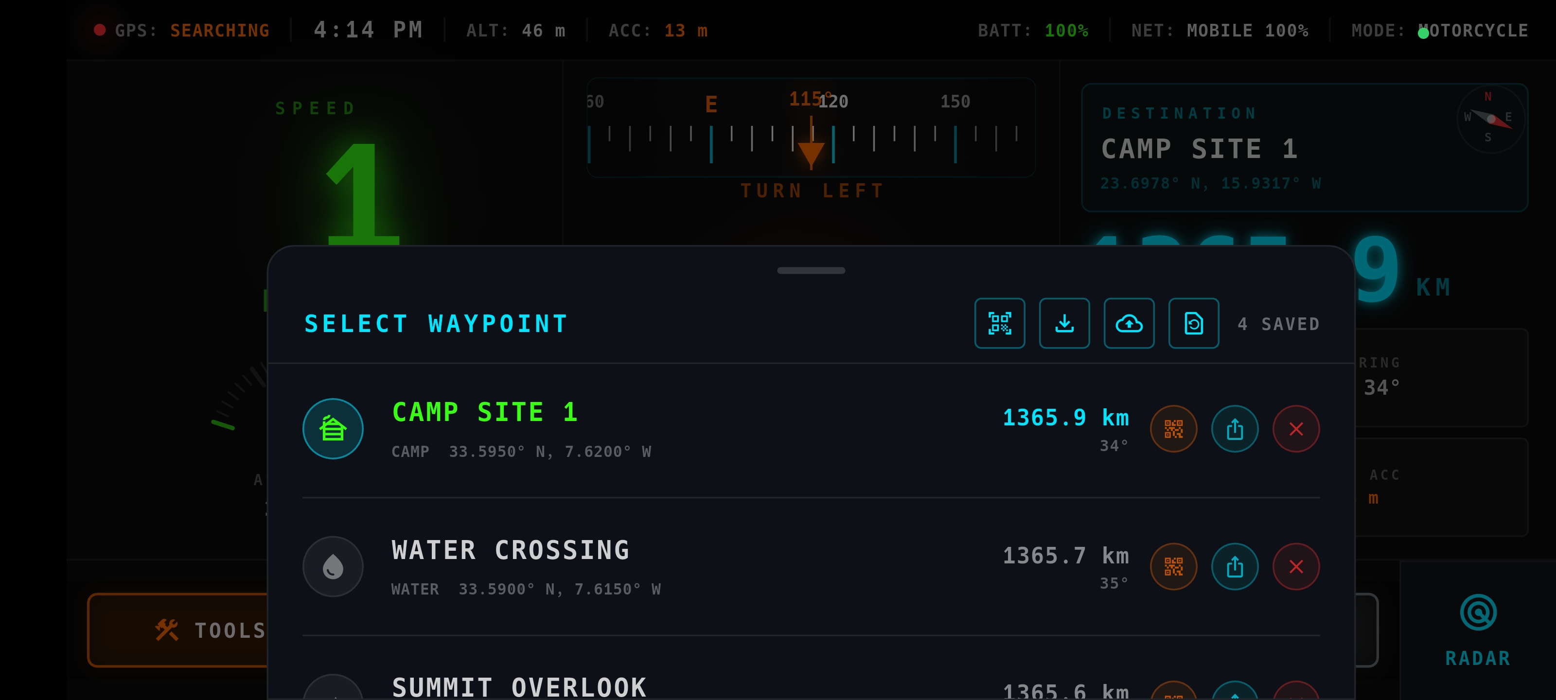
Save, Import and Export Locations

Full GPX workflow — save current position, import from file or clipboard, export your recorded track as a standard GPX.

  • 1Tap Save to store your GPS position with a custom name
  • 2Open Tools → GPX to export your full recorded track
  • 3Pick a GPX file from device storage to import a route
  • 4Paste GPX XML from clipboard for quick import
  • 5Roadbook auto-lists all waypoints with cumulative distances
GPX ImportGPX Export RoadbookClipboard
Tools
04 — Tools & SOS Emergency

Trip Meter, Roadbook & Emergency Share

All utility tools in one panel. The SOS button can save your life when riding solo in a remote location.

  • 1SOS: instantly shares lat/lon/altitude as a text message
  • 2Trip Meter: total distance, partial distance, elapsed time
  • 3Reset partial counter at any checkpoint
  • 4Roadbook: auto-generated list with cumulative distances
SOS ShareTrip Meter RoadbookHaptic Alerts
Settings
05 — Voice & Settings

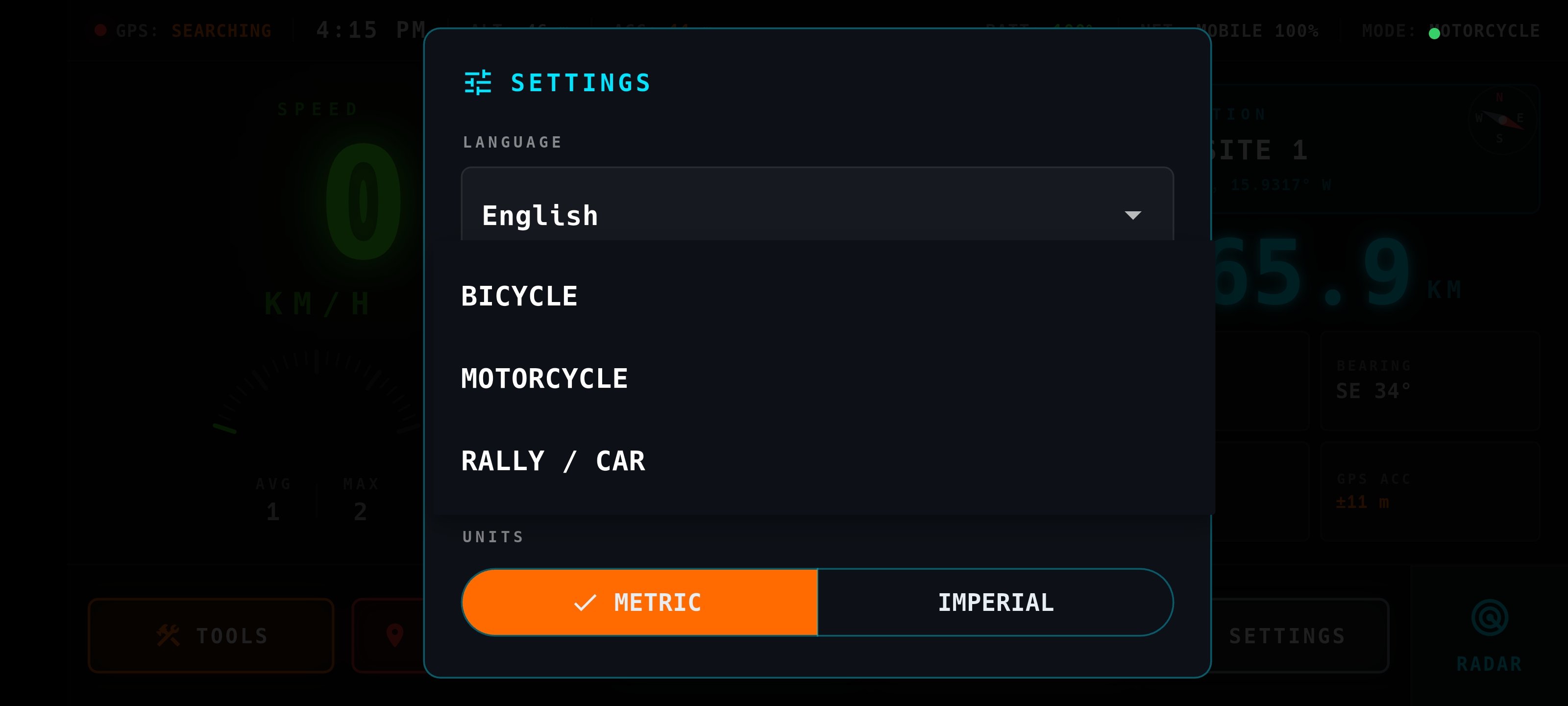
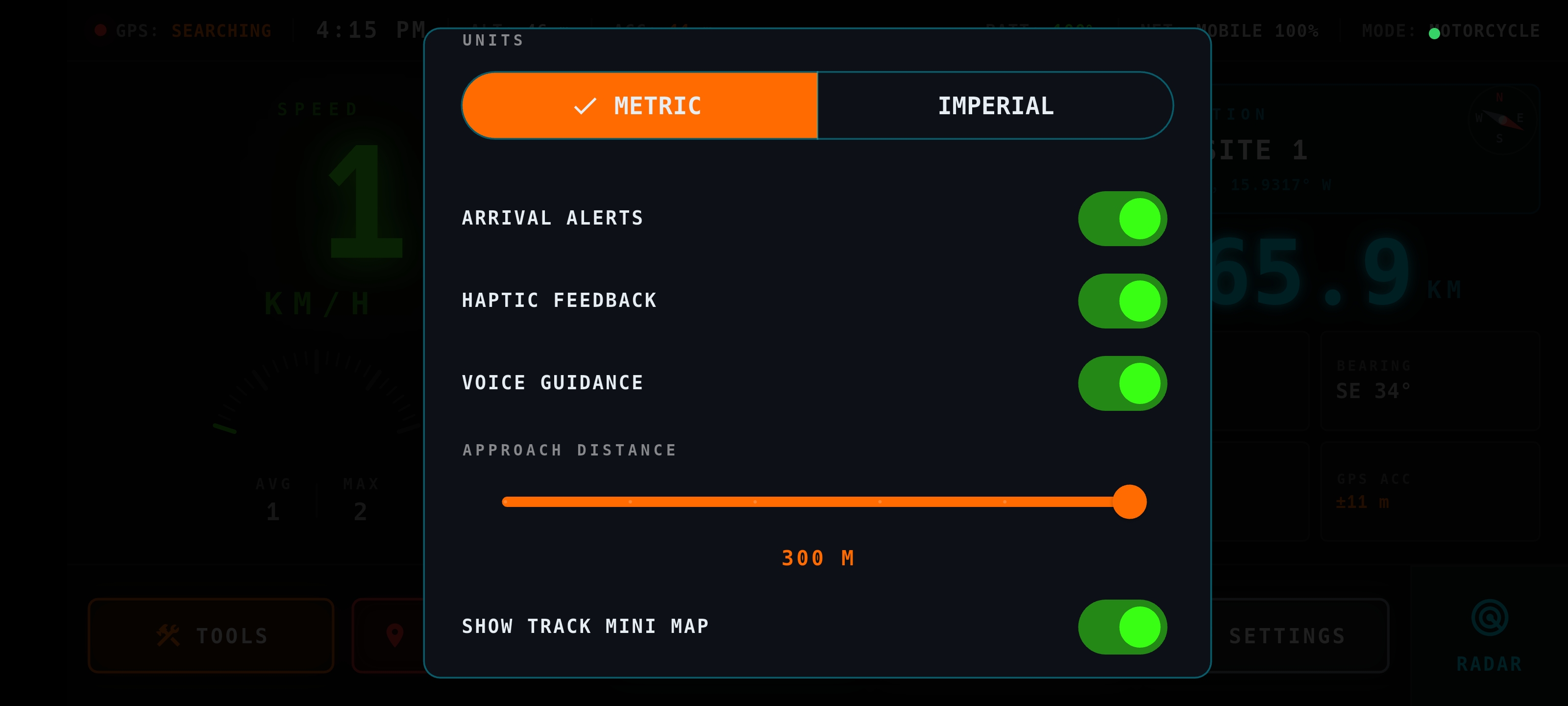
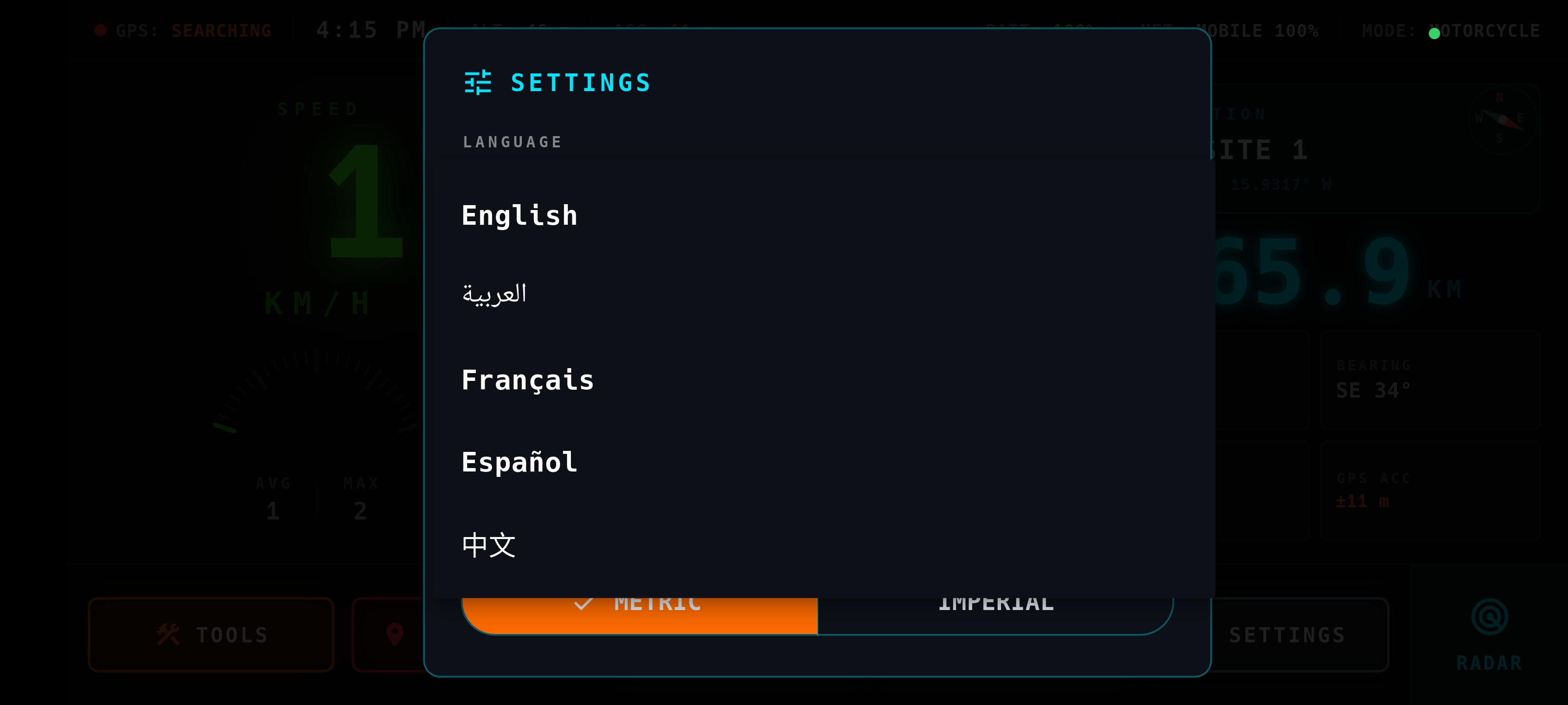
Configure for Your Vehicle & Language

Choose your adventure mode, voice language, unit system and alert preferences to match exactly how you ride.

  • 1Adventure Mode: Bicycle · Motorcycle · Rally — sets speed scale and approach distance
  • 2Voice guidance in: English · العربية · Français · Español · 中文
  • 3Toggle haptic vibration on waypoint arrival
  • 4Switch between km/h and mph
  • 5Show or hide the mini map overlay
5 LanguagesVoice TTS Haptickm/h · mph
Navigation Arrow Forward
06 — 3D Navigation Arrow

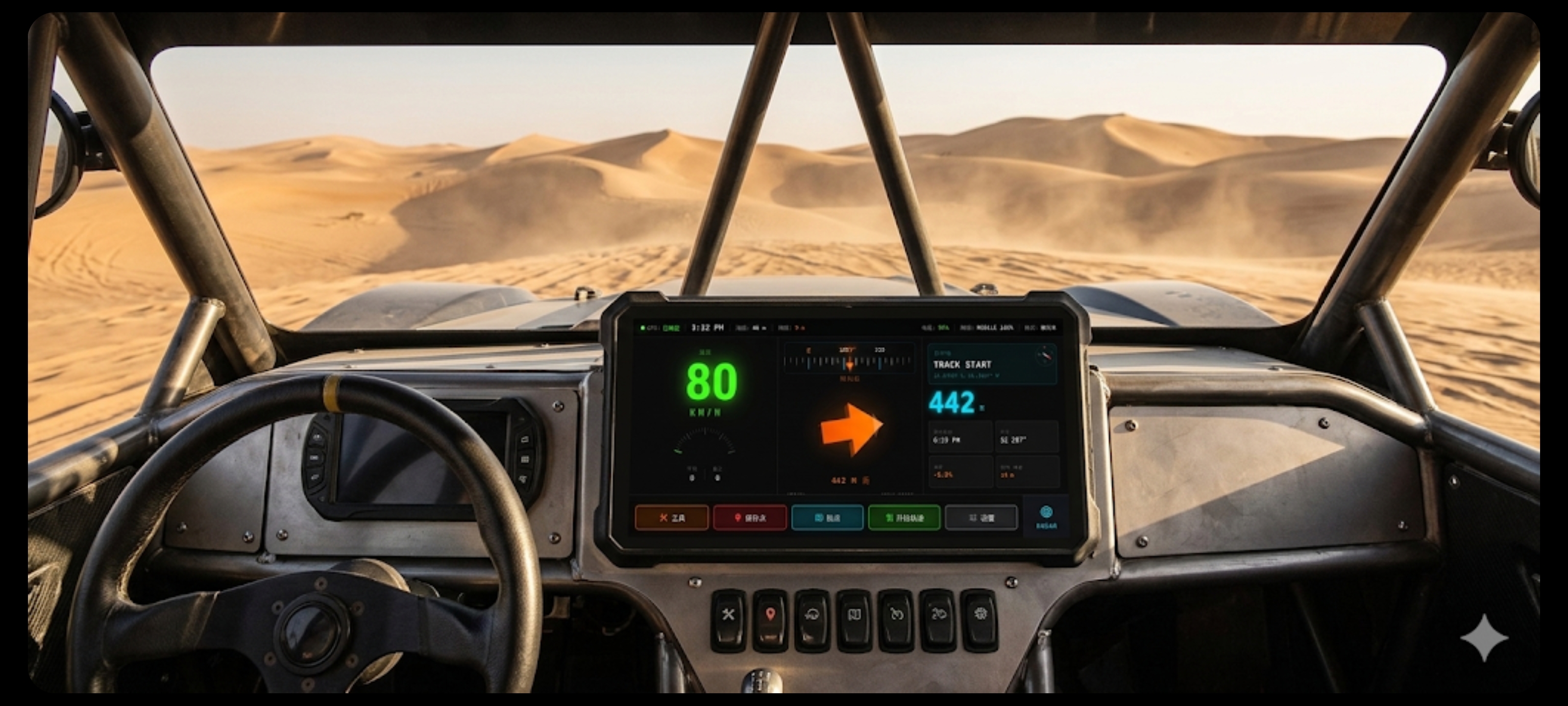
Real-Time 3D Directional Arrow

The large 3D arrow always points toward your next waypoint in real time, rotating smoothly as your heading changes. No map reading required — just follow the arrow.

  • 1Arrow rotates based on live GPS heading vs. waypoint bearing
  • 2Color changes: green (on track) → orange (deviation) → red (far off)
  • 3Distance to waypoint displayed in large digits below the arrow
  • 4Works 100% offline — no internet or signal required
3D ArrowLive Bearing OfflineColor Coding
Map View
07 — Offline Map View

Full Offline Map with Track Overlay

View your loaded GPX route overlaid on a cached offline map. See your real-time position, track progress and remaining waypoints — even in areas with zero cellular coverage.

  • 1Cache tiles in advance via Wi-Fi before heading out
  • 2GPX track drawn as a colored line on the map
  • 3Your position marker updates in real time
  • 4Zoom in/out with pinch gestures
Offline TilesGPX Overlay Live PositionZoom
Radar View
08 — Radar Page

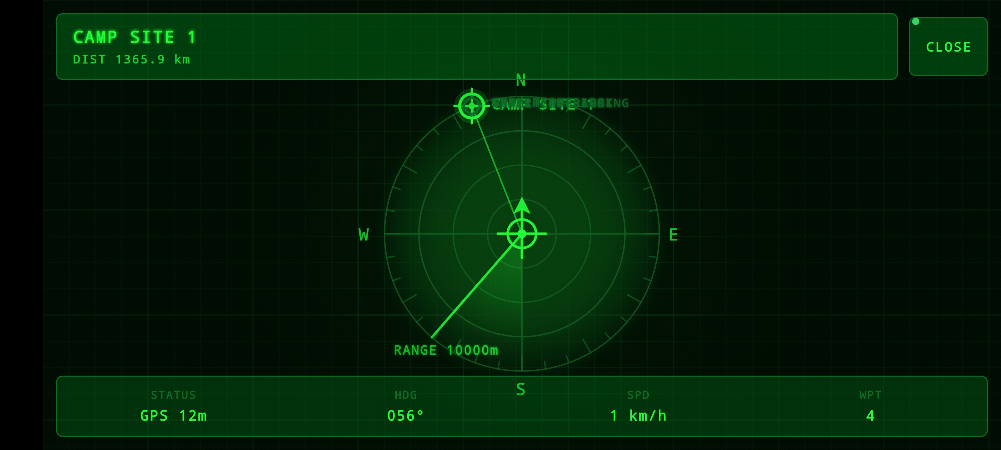
360° Radar — All Waypoints at a Glance

Switch to Radar view to see all your loaded waypoints as blips on a circular radar scope — instantly knowing which ones are ahead, behind or to your sides.

  • 1Your position always at the center of the radar
  • 2Waypoints plotted by true bearing and distance
  • 3Next active waypoint highlighted in neon green
  • 4Tap a blip to jump to that waypoint
360° RadarAll Waypoints Tap to SelectBearing + Distance

Built for every
off-road vehicle

Each mode auto-adjusts the speed scale and waypoint approach alert distance.

Bicycle mode

BICYCLE

Mountain bike trails and gravel paths. Waypoint alert at 50 m — ideal for low-speed technical terrain.

MAX 80 KM/H · ALERT 50 M
Motorcycle mode

MOTORCYCLE

Enduro, trail and adventure bikes. Alert at 100 m for enough reaction time on rough terrain.

MAX 180 KM/H · ALERT 100 M
Rally mode

RALLY / 4×4

Buggies and rally cars. Alert triggers 200 m ahead so driver and co-driver prepare at high speed.

MAX 240 KM/H · ALERT 200 M
Fishing / Marine mode

MARINE / FISHING

Navigate to fishing spots, buoys and anchorages at sea. Works far from shore with zero signal.

FULLY OFFLINE · NO SIGNAL
🚀 No Account Needed

Start your
adventure today

Download GPS Arrow Pro and navigate anywhere on Earth — no internet, no subscription, no limits.

GPS Arrow Pro Download Now
7-Day Trial Android 6.0+ No login 100% offline
SHA-256: 47a4a2905615e7095d2023c25db94fcb2526526d04e7e2cb24a4e431338d77c0

GLOBAL REACH

GPS Arrow Pro trusted by off-road navigators worldwide

DOWNLOADS
COUNTRIES
SUBSCRIBERS
LIVE MAP

Riders Around the World

You are here. Join the community.

VISITOR WALL

Riders around the world

Leave your mark — where are you riding from?

0/300